We know more about the surface of most of the planets in our solar system than we do about the largest habitat on Earth: the ocean. But scientists worldwide are fighting to change this, and a global effort is currently underway to map the entirety of the seafloor.
The Seabed 2030 project, launched in 2017 by two non-profits—the Nippon Foundation, and the General Bathymetric Chart of the Oceans (GEBCO)—aims to achieve this ambitious goal by the end of the decade, and make this data freely available to all. At the time of the project’s launch, less than 6% of the ocean’s floor had been mapped to an acceptable modern resolution, and whilst this has expanded year-on-year—reaching 23% in June 2022—the equivalent of twice the surface area of Mars still remains to be charted.
Bathymetric (depth) measurements can be taken in a variety of ways. Echo-sounding measures depths by bouncing sound waves off the seafloor, and LIDAR (light detection and ranging) employs a similar principle using laser pulses. Satellite altimetry is another method, which exploits the fact that submerged topographical features cause gravitational bulges in the ocean’s surface. These bulges can be detected by bouncing radar pulses off the water’s surface from satellites, providing information on the geography of the depths below. But these methods are all expensive, and boats recording bathymetric data generally have to travel slowly, limiting the area that can be covered in one trip.
While scaling up these scientific efforts is undoubtedly crucial, their expensive and time-consuming nature means that large-scale international collaboration is key for meeting the 2030.
Satellites, submersibles, and ships owned by private companies and governments have been mapping large swathes of the ocean to high resolutions for decades—but this data is generally locked away in archives, hidden from the public eye. The Seabed 2030 project aims to combine these groups’ efforts, pooling crowdsourced data in an unprecedented way. For this, effective public communication on the common benefits of sharing this information will be critical. But a trade-off will also be required to balance having mapping resolutions which are high enough to be of scientific value, but low enough for these stakeholders to feel comfortable that their commercial or defence secrets are not at risk.
Known unknowns: what’s down there?
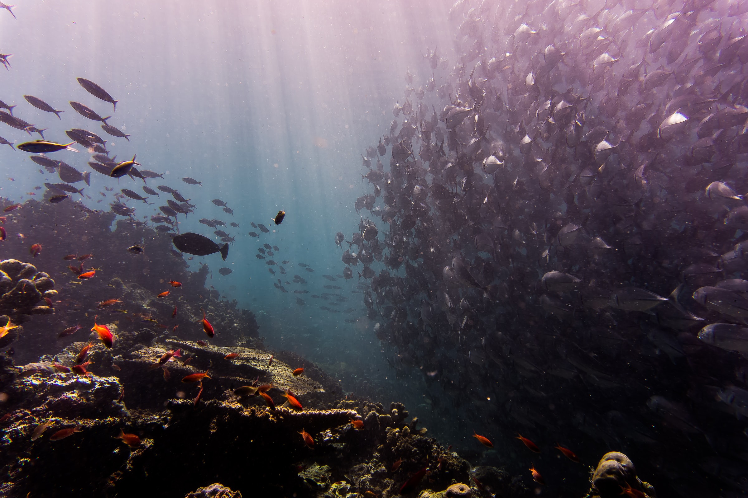
Approximately 70% of the seafloor consists of abyssal plains—flat expanses of sediment found offshore from continental shelves, at 3,000m or more below sea level. But like dry land, the ocean’s floor is broken up along tectonic plate boundaries by dramatic geological features. At convergent boundaries, where one tectonic plate is forced under another and sinks into the Earth’s mantle, deep-ocean trenches can form. This is how the famed Marianas Trench of the Western Pacific was formed–the deepest point on Earth, at over 10km below sea level.
In contrast, where tectonic plates spread apart at divergent boundaries, eruptions of basalt form mid-ocean ridges consisting of chains of deep-sea volcanoes, called “seamounts”. These are hotspots of deep-sea biodiversity, harbouring starkly different species to those of the surrounding water. Unlike soft seafloor sediments, seamounts provide a hard rock surface on which reef-forming organisms like cold-water corals, sponges, mussels, and barnacles can attach and grow. Seamounts also modify the deep-water currents which flow past them, creating whirlpool-like effects around their summits which concentrate and retain plankton and organic matter.
Whilst food is generally scarce in the deep sea, this retention effect allows seamounts to support an abundance of animals like crabs, sea urchins, colourful sea slugs, and dense shoals of fish. They can even provide pit-stops for large, migrating animals like whales and sharks.

Other types of deep-sea habitat can also form at plate boundaries. At hydrothermal vents, seawater filters down through fissures in the Earth’s crust where it is super-heated by magma. This results in eruptions from below the seafloor, carrying dissolved minerals like sulphur and various metals from within earth’s mantle. These solidify as they come into contact with the cold, oxygen-rich water of their surroundings, forming towering mineral deposits over time, which resemble huge smoking chimneys and can be as tall as an 18-storey building.
Compounds like hydrogen sulphide and methane are the basis of food webs in these habitats, with deep-sea bacteria serving as the primary producers, using these chemicals as an alternative energy source to sunlight. In a comparable way to the retention of organic matter at seamount peaks, this alternative source of “chemosynthetic” energy in the nutrient-scarce depths means that vent communities are often dense hubs of marine life, supporting unique animals found nowhere else. These include giant tube worms, which possess neither a mouth nor anus, but feed entirely on symbiotic sulphur bacteria which they house within a specialised internal organ; and strange, furry ‘Yeti crabs’ (discovered in the South Pacific Ocean in 2005), which cultivate bacteria on the hair-like bristles covering their bodies, combing them periodically with their claws in order to feed.
Why does mapping the seafloor matter?
Despite the geological and biological diversity of deep-sea habitats, our understanding of them remains extremely murky. Globally, seamounts are estimated to rival tropical rainforests in their total area—but, despite being the planet’s most abundant geological features, very little is known about them. Although almost 13,000 have been recorded to date, this is thought to be just the tip of the iceberg. Ocean trenches are similarly poorly mapped, with the deepest point of the Southern Ocean—the Factorian Deep, lying at 7.5 km below sea level between South America and Antarctica—only recorded as recently as 2019.
Knowing the heights, depths, and locations of geological features like ocean trenches and seamounts is vital logistically, to ensure the safe navigation of ships and submarines. As our reliance on sustainable sources of renewable energy—like wind and tidal power, and algal biofuels—accelerates, knowledge of the seafloor’s topography will also become increasingly important for the effective placement of structures like wind farms and their associated undersea cabling.

Aside from these needs, mapping the seafloor will play a vital role in other key efforts of the 21st century, such as the forecasting of climate change. The ocean is a key player in Earth’s climate, with ocean currents and the vertical mixing of seawater determining how solar radiation hitting the planet’s surface (most of which is water) is redistributed throughout the globe. Yet, the exact locations of deep-sea features—and how they interact with deep-ocean currents to influence the distribution of heat—are not yet fully accounted for in the Earth System Models used to forecast climate change. This represents a significant gap in our current knowledge, and one which must urgently be addressed if scientists are to adequately inform policymakers of the impacts of different emissions scenarios.
Moreover, marine sediments represent one of the planet’s most significant reservoirs of carbon, but clear estimates of the amount of carbon stored in the seafloor globally are still currently lacking. At present, seabed carbon stocks are estimated by averaging their organic carbon density across their global area. But this method often fails to consider variations in the topography and chemical composition of different regions of the seafloor, such as continental slopes, abyssal plains, and the bottom of ocean trenches.
Improving our estimates of the current state of marine sediment carbon stocks is vital. Disturbing sediments through activities like deep-sea drilling, seabed dredging, and bottom trawling remineralises the stored carbon to CO2, which can then re-enter atmospheric fluxes. Improving maps of marine sediment carbon stocks will open up the opportunity to design marine protected areas (MPAs) which maximise the protection of both stored carbon and marine life, combatting climate change and biodiversity loss simultaneously.
Biologically, deep-sea ecosystems are also among the least studied on the planet, and mapping the seafloor will facilitate the scientific exploration of currently undiscovered habitats.
Practically every research expedition into the deep yields scientific descriptions of new species, with no sign of the rate of discovery plateauing. Indeed, in July 2022 a single expedition into the Clarion-Clipperton abyssal plain (situated between Mexico and Hawaii) revealed over 30 species previously unknown to science.
Many deep-sea species, like corals and sponges, can live for hundreds or even thousands of years, but very little is currently known about their basic biology and how they achieve this feat. Studying these species could therefore provide us with novel insights into processes like ageing, cancer, and biological immortality, and yield a potential pharmacological revolution. Other aspects of deep-sea life—such as how evolution operates in the absence of sunlight and photosynthesis at hydrothermal vents—are also of interest to scientists studying the possibility of life on other planets.
A double-edged sword
Cataloguing the biodiversity of newly mapped seafloor habitats is more urgent than ever. Deep-sea life is a major component generally missing from most estimates of biodiversity loss, and the conservation status of most species found in deep-sea habitats is largely unknown. This represents an Achilles’ heel for global conservation efforts, because as well as being the least-studied ecosystems on the planet, deep-sea communities are also among the planet’s most threatened.
As the search for seafood moves deeper into the ocean due to the unsustainable depletion of surface fish stocks, deep-sea fish—particularly the rich aggregations found on seamounts—are becoming an increasingly attractive prospect to fisheries. However, it is harder to reach deep-sea fish than those dwelling close to the surface, so vessels are resorting to alternative and more destructive methods of fishing, like bottom trawling. This involves dragging heavy nets along the seafloor – which is comparable to clear-cutting a forest to catch squirrels. Cold-water coral reefs and sponge gardens are bulldozed in the process, and up to a third of the total catch of seamount fisheries can consist of the shredded fragments of dead corals.

Deep-sea drilling in search of gas and oil reserves is also common, destroying entire habitats and choking the few remaining survivors with oil spills. Deep-sea mining is similarly destructive. And yet, as terrestrial reserves of metals like copper, manganese, cobalt, and zinc begin to run dry (whilst their demand for use in batteries continues to skyrocket), this is also on the rise.
Mapping the seafloor is therefore problematic, as the only protection that many deep-sea habitats currently have is their obscurity. The open availability of a complete, high-resolution map of the seafloor by 2030 risks unleashing the full force of the fishing, mining, and oil industries upon deep-sea marine life unless we act now.
Many deep-sea habitats would qualify for legal protection as coral reefs or areas of special scientific interest—but, to gain this protection, research missions are needed to catalogue the biodiversity present.
However, big mining or fishing companies are generally able to send fleets of vessels to newly discovered vents or seamounts much more quickly than research groups. In this race between scientific discovery and commercial exploitation, deep-sea species risk becoming threatened practically as soon as they are discovered. A short- to medium-term moratorium on commercial activities in the deep-sea is therefore urgently needed, whilst scientific efforts to chart the seafloor and assess its biodiversity are massively scaled up.
Furthermore, we urgently need to re-think our international legal frameworks concerning the high seas, located outside of any single nation’s jurisdiction. This is where many deep-sea habitats, like seamounts, are often found—but the high seas are currently an example of the tragedy of the commons, widely considered to be everyone’s right but no one’s responsibility. This mentality fosters unsustainable, boom-and-bust operations which simply aim to make as much profit as possible before the resource disappears—whether it be fish stocks, metal deposits, or oil.
Addressing these challenges is no small undertaking, and no-one today can claim to have all of the answers. But we can no longer afford for the seafloor to remain out of sight and out of mind in our discussions of climate change and biodiversity loss. Whilst mapping the seafloor is necessary for navigation, marine infrastructure, climate change forecasting, the assessment of marine carbon stocks, and scientific research, this knowledge also comes with an enormous amount of responsibility. The question is: will we learn from our past mistakes, and ensure that future usage of the deep sea is responsible and sustainable? Only time will tell.